German geographical game - possibly pre-ww1 - 1910

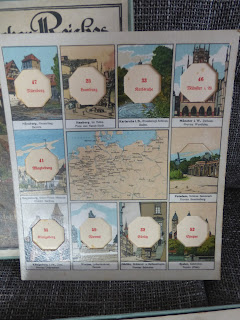
The original box cover bears the title "Städte des deutschen Reiches“ and measures 315 x 290 x 40 mm in fairly good to good condition: this is the Scholz company game Nr. 430. Ein geographisches Lottospiel mit Bildern von Emil Heinsdorff. Grosse Ausgabe. Verlag von Jos. Scholz, Mainz.
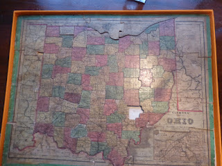
There has been one clumsy repair to the box lid, but it still baers the maker´s original label on one side. The box contains six map cards of Europe each measuring 275 x 240 mm (with the map only 80 x 115 mm in centre) and having attractive pictures of 10 important cities, each named at the bottom of the image. For each city illustration an octagonal centre portion must be extracted as a playing counter. Each of these counters when removed shows the name of the city and is numbered (e.g. 33 Karlsruhe, 35 Königsberg - now Kaliningrad) and the counter is likewise numbered but also has a question: 33 Wie heisst die Haupstadt von Baden? (What is the capital of the area Baden?) or 35 Welches war die Krönungsstadt der preussischen Könige? (Which city was the coronation site of the Prussian kings?) and these are all in the sutterlin style of writing prevalent before WW2. The game rules are printed (in German of course) on the inside of the box lid.
All in very nice condition, only played with a couple of times (from condition of counters) and believed to be complete. From the area shown on the maps it most likely dates to circa 1910.


The game is for sale for €125 which includes free postage and insurance and tracking.

Comments
Post a Comment