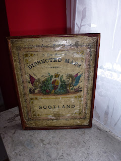
Map of Scotland in 45 irregularly shaped pieces measuring 230 mm x 280 mm (complete but one piece is a modern replacement). Victorian style printing on paper and laid on to thin single-thickness (i.e. not plywood) board before cutting into pieces which are mostly the approximate shape of county depicted. Board reverse was covered with plain green paper before cutting. Map reminiscent of Philips. Wooden box with Royal arms illustration has imprint “WILLIAM PEACOCK, LONDON.” in frame. Box split across bottom with no real loss. Includes fold-out copy of completed map at measuring 230 mm x 280 mm with imprint “GALL & INGLIS, 6 GEORGE STREET, EDINBURGH” below centre.
WARDS puzzle Map of United States – Handcut – Number 48-650 – Montgomery Ward. This puzzle was handcut using 3-ply wood. The puzzle is double-sided and has a map of the USA without Alaska on one side and a map of US held territories on the other: Rand McNally Puzzle Map of the United States ; and Rand McNally Puzzle Map of the United States and Possessions showing territorial growth and geographical distribution (shows historical growth within US). The pieces are amazingly intricate and not always interlocking. The central pieces which show US states are cut into state outline. Map measures 38 x 45 cm. The box is the original from the 1930s (estimated) but has been recovered. At some point the box suffered from water / damp and the outer fabric was badly affected. I recovered the box in a material similar to original (a small piece is included for comparison) and the original label reused. The base has the original stamp. As mentioned, at some point the puzzle was exposed t...
Comments
Post a Comment